
- * 프린트는 Chrome에 최적화 되어있습니다. print
지구환경도시건설공학과 / Department of Civil, Urban, Earth, and Environmental Engineering

임정호 Jungho Im
지구환경도시건설공학과 / Department of Civil, Urban, Earth, and Environmental Engineering
 +82-52-217-2887
 ersgis@UNIST.AC.KR
 http://iris.unist.ac.kr
 Bldg. 110 Rm. 1003-1
Curriculum Vitae
· 2019⎼present: Full Professor, UNIST
· 2014⎼2019: Associate Professor, UNIST
· 2012⎼2014: Assistant Professor, UNIST
· 2007⎼2012: Assistant Professor, Environmental Resources Engineering, State University of New York, College of Environmental Science and Forestry
· 2006⎼2007: Research Associate, Center for GIS and Remote Sensing, University
Academic Credential
· 2006: Ph.D. in Geography, University of South Carolina
· 2000: M.C.P. in Environmental Management, Seoul National University
· 1998: B.S. in Oceanography, Seoul National University
Awards/Honors/Memberships
· 2014⎼present: Editor-in-Chief, GIScience and Remote Sensing
· 2020⎼present: Associate Editor, ISPRS Journal of Photogrammetry and Remote Sensing
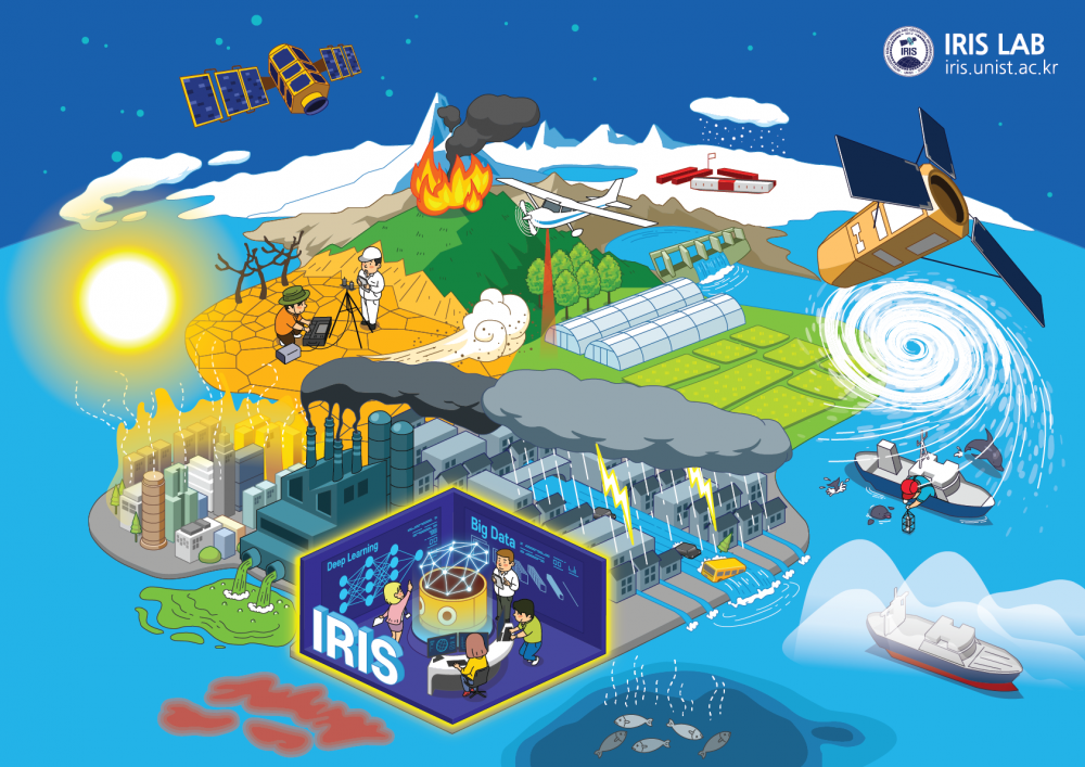
IRIS 랩의 주 연구분야는 원격탐사 자료와 공간 정보, 인공지능을 활용하여 변화하는 기후 속에서 지구상에서 나타나는 다양한 현상들을 이해하고, 모니터링 및 예측 분석하여 지구 시스템을 보다 더 잘 이해할 수 있도록 하는데 초점을 두고 있다. 특히 최근 들어 많은 이슈가 되고 있는 폭염, 태풍(집중호우), 미세먼지, 가 뭄, 산불 등 재난재해 분야에 집중하고 있으며, 다양한 소스의 관측 및 모델자료와 최신 인공지능 기법을 융합하여 연구에 활용하고 있다.
The IRIS lab utilizes remote sensing, GIS modeling, and artificial intelligence techniques to broaden and deepen our understanding of the Earth science under climate variability/change, and leverages this knowledge to better manage and control critical functions related to terrestrial, coastal, and polar ecosystems, natural and man-made disasters, water resources, and carbon sequestration.
Major research field
원격탐사, 인공 지능, 공간 모델링, 재난 모니터링 및 예측 / Remote sensing, artificial intelligence, spatial modeling, disaster monitoring and prediction
Desired field of research
Research Keywords and Topics
· 원격탐사와 AI 융합 활용한 재난 모니터링 및 평가
Disaster Monitoring and Assessment using Remote Sensing and Artificial Intelligence
· 극지 원격 탐사
Polar Remote Sensing
· 대기질/기상/기후 원격탐사
Remote Sensing for Air Quality, Meteorology, and Climate
· 수자원 및 해양 원격탐사
Remote Sensing for Water Resources and Ocean
Research Publications
MORE· Lee, S., Yoo, C., Im, J.*, Cho, D., Lee, Y., Bae, D. (2023). A novel approach to investigating the changing urban thermal environment by dynamic land cover transformation: A case study of Suwon, Republic of Korea. International Journal of Applied Earth observation and Geoinformation, 122, 103408
· Choi, H., Park, S., Kang, Y., Im, J.*, Song, S. (2023). Retrieval of hourly PM2.5 using top-of-atmosphere reflectance from Geostationary Ocean Color Imagers I and II. Environmental Pollution, 323, 121169
· Jang, E., Kim, Y., Im, J.*, Park, Y., Sung, T. (2022). Global sea surface salinity generated through the synergistic use of SMAP satellite and HYCOM data based on machine learning approaches. Remote Sensing of Environment, 273, 112980
· Son, B., Park, S., Im, J.*, Park, S., Ke, Y., Quackenbush, L. (2021). A new drought monitoring approach: Vector-Projection Analysis(VPA). Remote Sensing of Environment, 252, 112145
국가과학기술표준분류
- ND. 지구과학(지구/대기/해양/천문)